Get consult
Unlock the secrets of the world’s most breathtaking locales with our expert insights — guiding you toward the truly remarkable destinations that define a lifetime of travel.


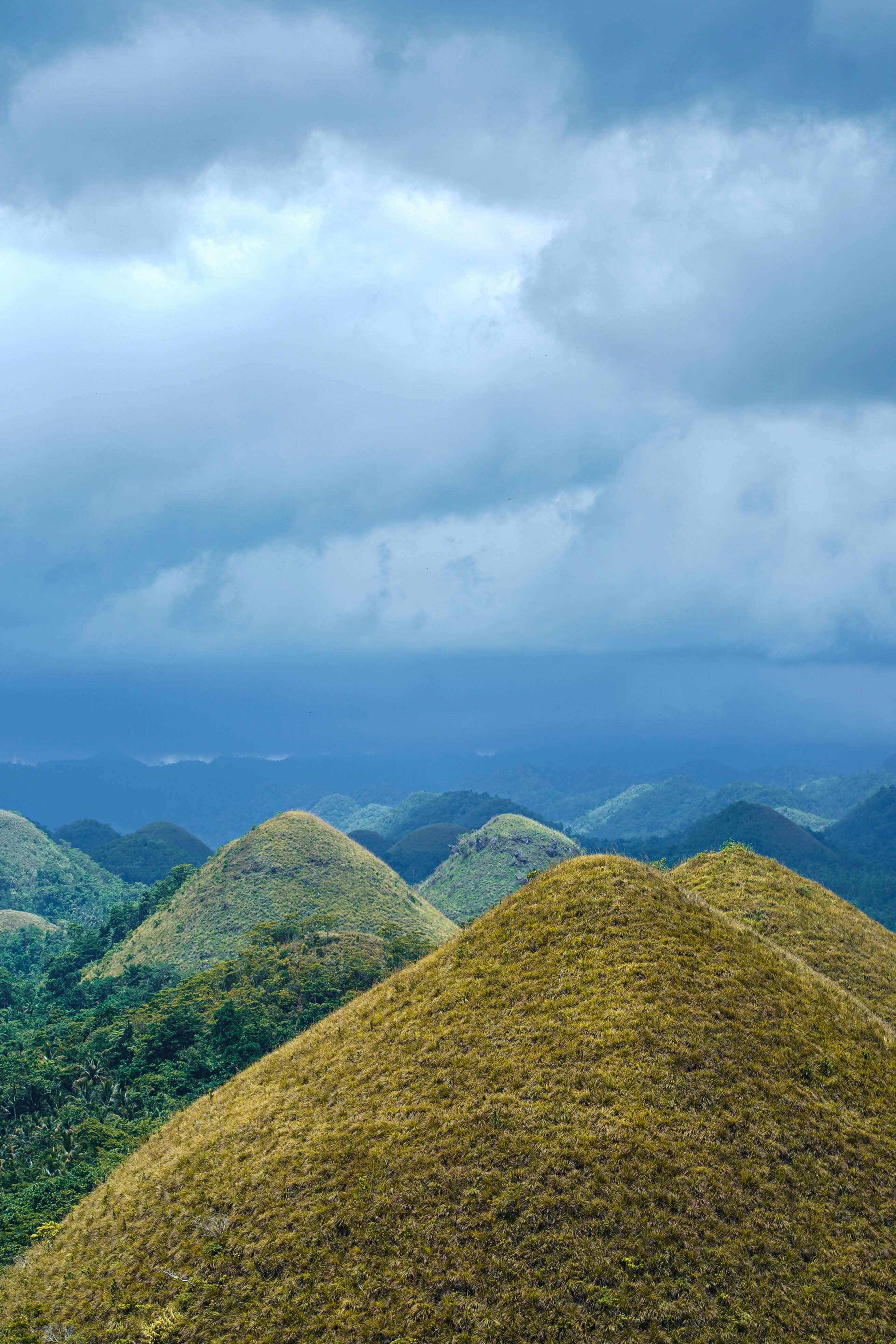
Photo by Jerome Ramos 🇵🇭 on Unsplash
From above, they look like a sea of chocolate drops scattered by a careless god: more than 1,200 near-perfectly conical hills rising from the flat plains of central Bohol, each one covered in coarse grass that burns chocolate-brown in the dry season and glows vivid green when the rains return. The Chocolate Hills are one of the most recognizable natural formations in all of Southeast Asia — and one of the least understood.
Most visitors arrive for the view, snap photographs from the platform at Carmen, and leave. But beneath the postcard image lies a far more complex story: of pre-colonial giants, of geological mystery that has confounded scientists for centuries, of a declaration that opened the hills to quarrying, and of a community that fought, loudly and persistently, to save something that belonged to all of humanity.
The Chocolate Hills were declared a National Geological Monument on June 18, 1988, in recognition of their exceptional scientific and aesthetic value. But the protection came with complications. Archived government records and press coverage from the mid-1990s reveal a striking reversal: on September 26, 1994, President Fidel Ramos signed an amendment to Proclamation 468, formally reclassifying the land surrounding and lying between the hills as no longer part of the national monument — opening it to development by the provincial government and private entities.
This amendment, which took effect during the 1994 Sandugo celebration, allowed quarrying permits to be issued by the DENR and local governments within what had previously been protected land. Small-scale miners and quarry operators moved in, treating the karst formations as a source of construction material for the province's building boom. The very hills that had enchanted visitors for generations were being quietly broken apart from the inside.
Public backlash was fierce. Environmental groups, travel writers, and international heritage organizations raised alarms. In 1997, President Ramos signed a stronger proclamation — Proclamation No. 1037 — establishing the Chocolate Hills as a natural monument with genuine protections under the National Integrated Protected Areas System. The hills survived. But the debate over development versus preservation was never fully resolved, and mining pressures continued into the 2000s.
Long before geologists began debating the karst limestone origins of the Chocolate Hills, the people of Bohol had their own explanations — and they were considerably more dramatic.
The most widely known Boholano legend holds that two giants, one from the north of the island and one from the south, met one rainy day when the ground was slick with mud and began hurling boulders, rocks, and clods of earth at one another in a ferocious battle that lasted for days. When they finally exhausted themselves and made peace, they left the island — but the mounds of mud and stone they had thrown remained behind, hardening into the hills we see today. Some scholars suggest this legend is a local adaptation of a broader pre-colonial Visayan creation myth, predating Spanish contact in 1565.
The more romantic version involves a giant named Arogo who fell deeply in love with an ordinary mortal woman named Aloya. When she died — as all mortals must — Arogo wept for so long and so deeply that his tears, falling to earth and hardening, formed the hills as a permanent monument to his grief. In the dry season, when the hills turn brown, the Boholanos say Arogo is weeping still.
The accepted geological theory is that the Chocolate Hills are the result of thousands of years of weathering of marine limestone that was uplifted above sea level by tectonic processes and then eroded by rainfall and subaerial forces into their characteristic conical shapes. A bronze plaque at the Carmen viewing deck summarizes this theory. Geologists note that similar — but less regular — karst formations exist on the island of Java, Indonesia, making the Chocolate Hills' almost mathematical symmetry one of the great geological puzzles of Southeast Asia.
The Chocolate Hills are located in the municipalities of Carmen, Batuan, and Sagbayan in Bohol, approximately 55 kilometers from Tagbilaran City. The main viewing complex at Carmen offers the most iconic panorama, reached by climbing 214 steps to an observation platform that surveys the hills in all directions. Sagbayan Peak offers an alternative viewpoint with a 360-degree view and fewer crowds.
From Tagbilaran City (the capital of Bohol, accessible by air from Manila and Cebu or by ferry from Cebu City), take a bus or join a countryside tour heading to Carmen. Most organized Bohol tours include the Chocolate Hills as part of a day-trip itinerary that also covers the Philippine Tarsier Sanctuary, Loboc River cruise, and the Man-Made Mahogany Forest.
The Carmen viewing deck is where nearly every tourist goes. For a richer historical experience, make time for the National Museum of the Philippines — Bohol in Tagbilaran City before heading to the hills. The museum's archaeological collection — pre-colonial pottery, tools, and artifacts — places the hills in the context of the people who have lived among them for thousands of years. The legends of Arogo and Aloya take on a different weight when you understand that they emerged from communities whose ancestors had been interpreting this strange landscape for millennia before the first Spanish ship entered Philippine waters.
Also consider visiting Baclayon Church (built in 1596, one of the oldest in the Philippines) and the site of the Sandugo blood compact in Tagbilaran — the first treaty of friendship between the Spanish and native Filipinos, signed on Bohol in 1565. Together, these sites reveal a Bohol that is far more layered than its chocolate hills alone could suggest.
The hills endured giants, grieving lovers, tectonic upheaval, government ambition, and tourist footfall. Whatever made them, they remain. And they will remain long after we are gone.
Kotor is a double-listed UNESCO World Heritage Site in Montenegro's fjord-like bay. Your fact-checked 2026 guide to the Adriatic's most layered medieval city and the rise of Western Balkans travel.
The Faroe Islands generated 1.4 billion DKK from tourism in 2025 while pioneering Europe's most innovative sustainable tourism model. Your fact-checked 2026 guide to the North Atlantic's most dramatic archipelago.
McMurdo Sound and the Ross Sea welcome only about 1,150 visitors per season. Your fact-checked 2026 guide to the world's most remote expedition and the huts of Scott and Shackleton.